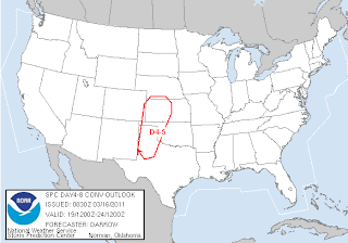
It looks like there will be a decent opportunity for supercells in far West Oklahoma and Texas panhandle Sunday through Monday. SPC has already outlined an area Saturday through Sunday.
I am actually most interested in Monday since chasing that day will be easier and it appears that it could have the most potential.
The ECMWF shows a nice surface low sitting over Southwest Kansas on Monday with a dry line extending south through the Texas panhandle. I can't tell how the wind vectors at the surface are aligned, but I have some hope that winds are not terribly veered along the dry line.
The GFS tells a slightly different story with a much weaker surface low and the main trough holding back further west. At least the moisture return is not expected to be the main problem.
The trough can be seen here further west and most of the disturbances well west and north of the target area. This might imply an even later set up... perhaps Tuesday, or even later. It also would likely mean that the best target would actually be in southern Kansas closer to the warm front and dry line bulge that can be seen on the dew point map.
CAPE is not overly impressive ether... but as some have pointed out the models have often underforecasted the CAPE. I won't bother to show it but there is also a pretty stout cap in place and it will be very hard to overcome that without some kind of upper level disturbance.
At least it is again something to keep a close eye on. All we really need is more instability... especially less CIN. Shear profiles look more than adequate for supercells.


No comments:
Post a Comment