Saturday, February 26, 2011

The Stench of the Early Season Setup

Well, Sunday looks to have what would be a great set up across the Red River on northward except for the stinking strong cap in place (made worse by the unbroken stratus deck forecasted by the NAM) and low cape. I mean there appears to be hope... and yet not.
The model does indicate some lifting of the cap towards evening and some decent lift along the dry line (especially near the Red River).
But the NAM fails to initialize thunderstorms except for in far eastern Oklahoma a little later in the evening.
By 6pm in the Ardmore Oklahoma region this is what the 00z NAM gives for a sounding...
Part of the problem is all the warm air advection stratus around 925mbs. It has pretty much prevented any significant warming from taking place.
This system still does bear watching however... especially if any clearing takes place along I 35.

The really bad news about this set up is the nocturnal tornado outbreak potential across Arkansas. The moderate risk area does not appear to be tapped into until after midnight making for a pretty nasty situation.

Monday, February 21, 2011

Active Active Active I hope...

While not I am not too excited about Thursday's event due to not being able to chase it and it being in the woods of northeast Texas, I am at least pleased to see that the models want to keep the pattern active. The GFS shows a system coming through Sunday/Monday-ish and another perhaps a week later.

The ECMWF:
Any way... it sure looks like the spring storm season is trying to get going and perhaps one of these events will yield some awesome chasing potential.

First Severe Threat of the 2011 Season for Texas

Looks like there will be somewhat of a severe threat in northeast Texas on Thursday.
At least it is the first chance of Thunderstorms for the DFW area in about a month or more.

Well for starters I am not sure how excited I can get. If I look at the 18z NAM for 21z Thursday I get this for CAPE:
Pretty downright awful. And I think part of the problem is its belief that thunderstorms will have already been initiated along the dryline... therefore preventing any further destableization for the afternoon.

The moisture out ahead of the dryline doesn't look bad at least. Especially since it is still February and it takes some work to get 60 dps in February. 

Shear doesn't look bad as well. About 50 - 60kts from 1000 - 5000mb.
The GFS basically looks the same but with a more aggressive push to the dryline into East Texas.

One other thing I forgot to mention is that the 12z run of the NAM was faster and more in line with the GFS. We will just have to see if the models are on a slowing trend. 

This basically reminds me right now of what happened with the first chase of last year. Storms fired east of I 35 and became severe well into northeast Texas and we never caught them due to there quick speeds.

If anyone is going to get pounded on Thursday it will probably be in Arkansas where the instability is greater due to 60 dps and colder temperatures aloft combined with stronger upper-level support. (Not to mention the much more favorably backed surface winds allowing for stronger low-level rotation.)

Tuesday, February 1, 2011

Thundersleet aftermath 2/1/2011

 This is one of those events that makes me glad I live in Texas. The continuously changing weather and forecast challenges are fun... at least to one who doesn't have to go driving out in the ice and doesn't have the pressure of a community demanding a decent forecast (and yes other states probably have greater extremes than we do here in Texas). To me it is always neat to see the variation God put into the weather and how he moves air masses however he wants to. I have said it once before, but I will say it again:
I hope that I never forget the majesty of my God and the wonder at all he has created. It is times like these that should remind us who is really master of creation.

When I got up this morning the temperature was around 16 degrees. Currently (as of 3pm) the temperature is just under 18 degrees.
Cold air seems to have filtered in a little faster than forecasted and the winter storm warning was extended further east.
During the night there were periods of very heavy sleet and occasional lightning. Some of the pellets looked like they were about a quarter of an inch across.
Ice totals seems to be about an inch deep across the yard and street with drifts over twice that in a few places.
We have also had snow flurries that are just now tapering off. It seems to be originating from clouds that are very low or near the surface and probably less than a thousand feet thick.


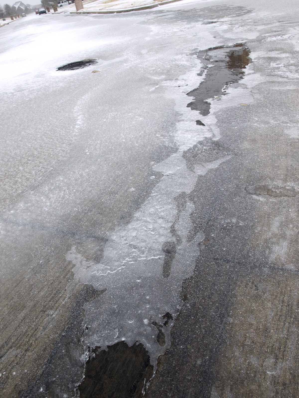
Water flowing under an inch of ice.


My very cold siblings.

About an inch to an inch and a half of ice on the sidewalk. 

Thought the fog on the lens when I brought the camera in from the outside made for some interesting atmospheric effects.

It always amazes me when I see the number of people that still drive out on the ice. There were at least a couple people that managed to get off to work. And there have been a few people on the Plano repeater calling in as "mobile". The mail man got stuck in our neighborhood after getting too close to the curb where water was flowing just under about a half-inch to an inch of slick ice. Thankfully he managed to get out with the help of a tow truck.

All in all it was quite an eventful winter storm.

Monday, January 31, 2011

Significant Winter Weather Event

From the National Weather Service in Ft. Worth:


SURFACE LOW IS CURRENTLY LOCATED ACROSS THE BIG BEND REGION AND
WILL BEGIN TO RAPIDLY MOVE NORTHEAST OVER THE NEXT FEW HOURS.
MEANWHILE...WIDESPREAD SHOWERS AND THUNDERSTORMS HAVE DEVELOPED IN
RESPONSE TO INCREASING LARGE SCALE ASCENT SPREADING EAST AHEAD OF
THE UPPER LOW. EXPECT THIS ACTIVITY TO CONTINUE TO INCREASE IN
COVERAGE THROUGH MIDNIGHT. LIGHTNING HAS BEEN ON THE INCREASE AND
THERE WILL BE SUFFICIENT ELEVATED INSTABILITY TO SUPPORT AN
ISOLATED SEVERE HAIL THREAT FOR THE NEXT SEVERAL HOURS. AS THE
SURFACE LOW DEEPENS AND MOVES NORTHEAST...MUCH COLDER AIR WILL
CONTINUE TO POUR SOUTHWARD ACROSS NORTH TEXAS. THERE APPEARS TO BE
A PERIOD OF TWO OR THREE HOURS WHERE SOME MODERATE FREEZING RAIN
COULD OCCUR...MAINLY ACROSS THE NORTHWEST COUNTIES FROM NEAR
GRAHAM TO BOWIE. LATEST FORECAST SOUNDINGS FROM BOTH THE 00Z NAM
AND 02Z RUC INDICATE THAT THE 1000-850MB LAYER WILL COOL QUICKLY
TO BELOW FREEZING SOMETIME AFTER MIDNIGHT...HOWEVER A STOUT WARM
NOSE WILL PERSIST AROUND 800MB INTO THE EARLY MORNING HOURS
TUESDAY. THE LATEST RUC ALSO INDICATES AS MUCH AS 350J/KG OF
ELEVATED INSTABILITY ATOP THE COLD AIR. THIS PROFILE SUGGESTS THAT
SOME IMPRESSIVE CONVECTIVE SLEET SHOWERS WILL BE POSSIBLE LATER
TONIGHT INTO THE EARLY MORNING HOURS. CANT RULE OUT THUNDER SLEET
FOR SEVERAL HOURS AS WELL. THERMAL PROFILES ARE MORE FAVORABLE FOR
SNOW MAINLY ACROSS THE NORTHWEST COUNTIES. THIS IS ALSO WHERE THE
LATEST NAM CONTINUES TO INDICATE STRONGEST FRONTOGENETIC ZONE AND
POTENTIAL FOR BANDED PRECIP TO SET UP.

GIVEN THE LATEST DATA...WILL LEAVE THE WARNINGS IN EFFECT AS
IS...BUT CHANGE THE PREDOMINANT PRECIPITATION TYPE TO SLEET AND
ISOLATED THUNDERSTORMS FOR MUCH OF THE AREA. WILL HAVE THE PURE
SNOW CONFINED TO THE NORTHWEST COUNTIES AND RED RIVER COUNTIES
THROUGH MORNING. LATER IN THE DAY ON TUESDAY...WE COULD SEE ALL
SNOW OVER MUCH OF NORTH TEXAS...BUT PRECIP SHOULD BE WINDING DOWN.
IN ADDITION...WILL BUMP UP ACCUMULATIONS IN THE METROPLEX TO 2 TO
3 INCHES...MAINLY SLEET ACCUMULATION.

 
Although many things are still uncertain at this point it appears that this storm has the potential 
to be one of the more significant winter storms I have experienced.On top of that temperatures next week 
are expected to be the coldest I have ever experienced in Texas.The Low temperature Thursday 
morning is expected to be right around 10 degrees... a very impressive hard freeze! 
(At least by my standards). 
 

Thursday, January 27, 2011

Winter Storm Maybe Tuesday?

This image pretty much summarizes thinking at this time.
The GFS doesn't have the front coming in until Tuesday afternoon which is considered to be too slow by the good people at the Ft. Worth WFO. 

Here is the 500 mb relative vorticity for noon on Tuesday according to the GFS. The trough is very strong and given that the highest vorticity maximum is still on the back side it isn't done digging.


At this point the GFS has a lot of precipitation breaking out across Texas and Oklahoma, but by the time temperatures drop below freezing Tuesday night moist of the precipitation is ended.
However given the amount of precipitation and given that it is not due strictly to lifting along the front but from the large trough digging into the west a significant icing event could occur if the front is 6 to 12 hours faster in this case.


Looks like a potentially nasty storm for Oklahoma and the Texas Panhandle at least.

Here is the 1000 - 500mb thickness. The critical 540 line (generally considered to be the rain snow line) is still pretty far north of the Red River according to the GFS.  


Here is an image from the ECMWF... looks quite a bit different. Its much faster with just about everything and even stronger with the trough. High pressure is already building deep into South Texas and northern gulf which indicates the front has already pushed deep into South Texas by 6am Tuesday. Not sure, but it probably doesn't have as much precipitation in North Texas guessing  by how far south the trough has dug  (not to mention its speed).

Monday, January 10, 2011

Winter Weather 1/9/2011

Didn't get any pictures of this event but it was pretty neat any way.
Snow began to fall Sunday morning around 10 am in the southern part of Collin County and continued for much of the afternoon. We received 2 or 3 inches which for a Dallas area snow is not bad at all.
The slightly anoying thing is that temps were 1 to 2 degrees above what they were forecasted to be over the metroplex which didn't allow for a quick change over to snow. By the time snow did begin to fall the upper disturbance responsible for the snow began to weaken as well as move east of the area. It seemed that a stronger disturbance took shape off to the east and a lot more snow occurred over in East Texas and beyond. It seems like I have noticed this trend many times before... where a wrap around snow band forms just to the west of us and as it approaches quickly diminishes in intensity.

Of course, now with all the cold air in place and the arctic left open  to unload more of these frigid airmasses into the central US, I have been looking ahead to see when the next winter precip maker will arrive. Nothing really catches my attention for a while but both the ECMWF and GFS continue to unload large high pressure systems from the west side of Canada down into the central US. Both the GFS and ECMWF occasionally sweep a disturbance across the area ahead of one of these very cold airmasses and as long as these keep showing up a chance exists for more ice.

In memory of the record breaking snowfall of February 11th 2010 here are a few images for your enjoyment (since I didn't take any this time around).