Saturday, December 1, 2012

July 12th 2010 Wedding Cake and Waterfall

Ok, I've finally decided to put together the chase account for July 12th 2010. This was probably the most photogenic storm I have ever scene thus far despite being a somewhat low shear HP Supercell that had some organizational issues. Given that this event was so long ago I can't remember all of the details but I'll see if I can put together what I do remember.

My understanding of severe weather was not really the best at this time, but I did know that a fairly unusual trough was to sweep through Oklahoma about the second week in July.The trough was unusual in that it was so far south into Oklahoma. Generally, if you can get cooler upper-level air along with the faster winds in the upper levels from a trough with a July surface air-mass you can get some fairly severe weather.  I do remember talking to James about a week in advance of the event, discussing the likelihood that it would be the last chaseable event for a few months, and thinking we needed to keep a watchful eye on the potential.

The trough did verify, though it was a little shallower and weaker than I would've liked... but hey! I can't complain about an Oklahoma storm chase opportunity in July.


I must lament the fact that this would've been Justin Terveen's very first storm chase had there not been miscommunication between us and him around leaving time. We did get things straightened out... once we were north of Oklahoma City... oooops. Hopefully he will forgive us... though that is not likely given the images that are to fallow.

Alright, I do need to mention somethings about the set up. I posted the 700mb to 300mb maps above. At the surface there was a cold front (or stalled front) across southern Kansas that provided the focus for some fairly intense supercells in the afternoon (at least a handful of tornadic ones in the Kansas, Oklahoma, Missouri  Arkansas four corners area). Prior to this a disturbance had been setting off thunderstorms in southern and eastern Oklahoma in the morning through the early afternoon hours. We knew we at least had to get away from the subsidence and clouds behind that mess.

Prior to the chase (maybe the night before) I had picked Clinton Oklahoma as my primary target. I wish I could remember why this was. It may have been that the NAM was consistent in blowing up thunderstorms along I 40 as another disturbance (along with the main trough access) approached. It may have been in conjunction with the expectation that the surface front in Kansas would sink well into Oklahoma. But, as we headed north on I 35 to get out of the mess to the south and east it became clear that the front was not going to make it into Oklahoma... except for maybe the Woodward area and we had no real desire to go that far north from Dallas. At this time being based in Dallas Texas Clinton Oklahoma was about as far as any of us were willing to go for a chase.

Well, the front was stalled in southern Kansas as we headed into 3:00pm and (other than the supercells in the four corners area of Kansas, Missouri, Oklahoma, and Arkansas) not much was going on. The storms further west in south central and southwestern Kansas looked like they were fighting a substantial cap... not that it really mattered given how far away they were from us.

We drove to Enid Oklahoma (the furthest north we had ever gone up to this time) and watched the struggle on the cold front that was too far away to chase anyway. Phooy. And when we saw the updated severe weather outlook from SPC we said another "Phooy". Junk to the southeast, now practically in Southern Arkansas, and some weak storms along the front chocking under what was probably a semi-stout cap were the only chasing options it seemed. What we really wanted were storms in West-Central Oklahoma.


I admit it. I probably prayed for storms. And there is probably some guy out there who, if he ever found out that I had, would likely want me to pay for his barn.

Well, God did give us storms and some of the most amazing I have ever seen. An outflow boundary which looked to be heading north from just south of I 40 seems to have partially been the culprit. And the rest was probably due to the main trough axis and associated lift combined with very unstable surface based air.


We headed west from Enid with heavy hearts when we noticed what we had been wanting to see all day: Towers exploding on the western horizon. Very interesting...
We charged into the Gloss Mountain area where an anti-cyclonic supercell was heading right for us. Boy were we excited.


Oh boy! oh boy! oh boy! oh boy! oh boy! 


It was beautiful and one of a very few strongly clockwise rotating storms I have ever seen.


While this storm was neat (with another anti-cyclonic cell coming quickly up on its heals) there was another Supercell to our southwest that was cyclonic, huge, and nearly stationary. Hmmmm... I really really wanted to try and make it to that cell. Unfortunately there were no roads that went directly to the storm... unless we wanted to core punch. I didn't really want to core punch too much... and James REALLY didn't want to core punch a potentially violent supercell (he was driving and it was his vehicle that would take the damage). So, we opted to make the hour long drive around to the southeast side of the storm.

I took a few more parting shots of the now shriveling anti-cyclonic storm and his little brother further west as we began the trip south and west.


While all this was going on our now good friend Ben Jacobi was in position on the monster HP supercell sitting near Putnam. He stuck with Clinton Oklahoma as a target throughout the day and it had really payed off thus far.

Here is a radar loop of the Putnam monster from about the time we arrived on it till about the time we
ended the chase. It really does not appear to have been very organized and cycles through mesocyclones fairly quickly. Even seems to make a brief transition to a bow-echo-like storm before developing a new meso. Whatever it was doing it did put on quite the show regardless, and even took out a barn (from SPC storm reports).

Boy was it a neat storm. At first the amazingness was probably only a moderate. But as it got closer the contrast increased and the mesocyclone tightnined up. Then amazingness quickly went off the charts.


Wow, things were really starting to look crazy. 


A developing microburst can be seen here.


Interesting circulation on the leading edge of the massive RFD gust front thingy. 


 Meso really began to tighten up and sometime in here Ben Jacobi met up with us for the very first time.


Somebody reported a tornado via ham radio. But it was never listed in the SPC reports. Still, it seemed possible that a funnel cloud wrapped back up in the rain. Really hard to tell though even with all the enhancements to this image.

I remember this being the first time I heard never ending thunder. That was quite an amazing sound. There were even a number of cloud to ground strikes fairly close by, though I didn't get a picture of one. They did, however, scare us further south a time or two.


Strange random microburst slams the ground just east of the mesocyclone creating this crazy image.


The amazing structure lasted for quite a while. I'm not sure how many stops we had made by this point. The storm was definitely moving south at a good 20mph now.


The last stop we made I believe was in Arapaho. The storm had begun to line out just a bit and redevelop again back to the southwest. We didn't really feel the need to stick around after such an amazing day and we still had a long drive back to Dallas Texas.


For more images from this Storm you can check out James Langford's page on Langford Photography.
A few of my images are in there as well. They probably don't look as good as some of the ones re-posted here because I messed up the color profile on most of them. Funny thing is the meso with the waterfall/microburst photo that I put on his site is probably more true to the original colors than the new updated one. Color is something I am still trying to figure out in my photography.

Well, that was an amazing day and one that has been very hard to beat. In a lot of ways it is still unmatched for photographic opportunities.

Thursday, June 7, 2012

Big Hailstorm, Tornado, and D-Magazine 5-29-2012

This was the first day of a two day severe weather event that we chased.
Unlike how the next days forecast would turn out this days was actually pretty good. Primarily because the models did a fairly good job and I had actually been looking over things carefully.

Chased with Justin Terveen, James Langford and Krista Higbee. Krista came on behalf of D-Magazine which was really neat. Hopefully I didn't say anything too stupid. ;)

The day and the next would be characterized by broad upper level flow across the central U.S. While not overly powerful it seemed as if it would provide enough deep layer shear for supercell thunderstorms. Around 35kts of shear, as it turns out, certainly ended up being plenty. Instability wouldn't be a problem either as it maxed out at about 4,000 j/kg near the Wotonga/Kingfisher area.

The Actual Sounding from Oklahoma City at 7pm only indicates ~3,000 j/kg and 33kts. Mesoanalysis on the SPC site would indicate 40kts or so with nearly 4,000 j/kg. 

OKC sounding 7pm


SBCAPE 6pm


0-6km Shear 6pm

The primary focus for storms would be a frontal boundary draped across the northern portion of Oklahoma a dryline to the west and strong convergence near the center of the surface low. In addition a disturbance would be rippling through the mid-level flow providing for additional lift.

The target area was essentially Watonga to Woodward Oklahoma. An area that was fairly close to the surface low and with surface winds backed to the southeast rather than south. This would enhance the overall shear and helicity just a bit more despite the lack of low level shear. Winds up to about 3km were pretty much aligned with only a bit of speed shear. So tornadoes were not really something I was expecting.

However, supercell thunderstorms in the right environment that latch onto boundaries or experience odd interactions with nearby cells may not care that low level shear is weak. This has been a well noted fact and why many chasers want to see a supercell thunderstorm interact with some kind of boundary. It all has to do with how winds change on a boundary and how low level shear and helicity might be considerably higher in the inflow region of a storm that is interacting with a boundary.

The reason I bring this up is because the storm that impacted the Kingfisher/Piedmont area produced a tornado (more than one?) despite the lack of low level shear and helicity after colliding with the outflow from another powerful storm to its south. What an incredible meteorological phenomenon that was to watch! Both storms then quickly fell apart after ingesting each others outflow. 

We left James' house around 11:00am and headed north on I 35 while giving Krista the Severe Weather 101 lesson which is really a condensed version of a skywarn class I guess. (Shear, Instability, and Lift)

Once on I 40 we teamed up with the DOW (Doppler On Wheels)... or more like passed them. It was, however, encouraging to see them heading the same direction we were.

We arrived just north of Watonga around 3pm and waited for storms to initiate. This consisted primarily of watching puffy cumulus clouds get bigger and bigger while we were getting sunburned. Finally noted some high clouds on the horizon just after 4pm associated with a beefy area of cumulus and assumed storms were firing.

The storms were slow moving and yielded some incredible explosive updraft motions. For a time we were able to sit under the developing mesocyclone as it organized near the town of Okeene while spitting some penny to nickle sized hail at us. This storm was also the southern most cell in a line of storms and therefore had the least obstructed inflow out of all of them.

The storm passed just to the northwest of Okeene by only a few miles. Interestingly the sirens in Okeene were blowing and we never knew the reason for it. The storm was high based at the time and there was no wall cloud (though mid level rotation was quite strong). There appeared to be some smoke in the town and perhaps a fire was the cause. Also, a number of dry microbursts were noted just north of town where the RFD was likely taking shape.

We were really cut off at Okeene since the storm was moving southeast right over highway 51 and there were no decent roads to take to the southeast to stay with the storm. Core punching was not really an option for those of us who dislike being beaten with large hail. We could've stayed on dirt roads but that is always a bit risky. We decided to drop south on highway 8 and then find another eastbound option.
I believe that eastbound option was Loyal Road as it was the only paved option and I don't even believe it was paved the entire way.

Whatever the road we took it east a little ways and that is when the storm started developing wall clouds. The first few were exciting... but not terribly exciting. (Actually most wall clouds for us are terribly exciting.) But with each wall cloud the storm would cycle through they would get lower and rotation would become stronger. In fact, the rotation at several points became very pronounced and very close to the tornadic storms I could compare it to. It really makes me wonder if it would've eventually put down a tornado anyway as it continued on into deeper moisture while surface temps cooled a bit in the evening. But we will never know since the storm collision of awesomeness took place at the critical "magic hour".

The first Wall Cloud by Justin

Another Wall Cloud by Justin


Wall Cloud image by James Langford

We dropped south out of Loyal to highway 3/33 and headed east into Kingfisher. It was about at this point that the storm was producing the Softball to Grape Fruit sized hail. Certainly not a storm we wanted to be cored by. We didn't really have time to stop as we barely made it through town before the storm as it was. Inflow was very impressive as well.


There was another cell immediately two our south that we had noticed earlier in the day. Not entirely sure where it originated, but it was likely a left split off of some storms closer to the Red River. It shot north at a fairly high rate of speed and was essentially on a collision course with our cell. The updrafts were extremely impressive with this cell as it came towards us. The situation was somewhat problematic for us because it looked as if we would be caught between the cells as they collided. Thankfully we were able to stop on the south side of Piedmont and just watch the process unfold.

The sky was simply crazy with stuff going on. We had the original cell to the north which was sucking in the outflow from the southern cell coming north and this made for tremendous wind at our location (tremendous being 40-50mph). We didn't have a great view of the southern cell as it merged given its meso was somewhat hidden at the angle we vied it from (the tail end of the RFD region I guess). So, we were most interested in the meso to our north on the original storm.

I can't really describe it but James' and Justin's pictures do a pretty good job.

Picture from James of the mesocyclone containing the developing tornado

Picture from Justin of the mesocyclone

Panoramic Image of the Mesocyclone from James

Panoramic Image of the Mesocyclone from Justin

There were actually a few areas of strong rotation, but the main circulation that the rain was wrapping around right in front of us produced the only known tornado.

Video of the tornado by James

Photo of the Tornado by Justin


The tornado was very brief but surprising to me. I had seen the circulation wrap up earlier and thought that it was done given that it appeared to have completely occluded. But the rain thinned out for a moment and there the funnel was! Thankfully it was brief and there was very little if any damage.

Another interesting point is that as this process unfolded the storm base seems to have raised. Likely due to the updrafts being chocked to some extent and the storm weakening. But it was right at the end of that that the tornado appeared.

The above radar loop should tell the rest of the story. The cells merged and spun up then immediately collapsed after ingesting each others cold outflow. We then had to find a way to get out of Piedmont and back south as another supercell quickly blew up on the outflow boundary set down by the original storm we  were chasing.

We managed to make one stop in Union City for lighting on this new cell before having to flee to the south again. At that stop there happened to be a civil defense siren not more than 50 feet from us. A tornado warning was issued for this new storm and the siren went off. I really didn't know how load those things were until now. As it made its sweep towards us the ground actually was vibrating.

New Cell Mesocyclone by Justin

Some lightning out of the Meso by James. Possibly from a different stop. 

Another from Justin


The day ended after a quick gas up stop which was cut short thanks to the new monster storm sneaking up on us quicker than expected. Given the 75mph plus winds expected with it along with the huge hail we figured we didn't need a full tank.

We quickly got back on I 35 and took it back home to Dallas where the large complex of storms eventually had an impact later that night.

In looking back all I can say is wow. The one day that we get somebody from D-Magazine to come along is the day that the forecast actually verifies and everything down to a tornado is witnessed. Wish I could say that my great forecasting skills was to be blamed for this but it isn't really. While I might have some (that God gave me) I am not the one who controls the weather. 

Tuesday, June 5, 2012

Texas Dusteater 5-30-2012

Haven't taken the time to write many chase accounts this year though there have been more successful chases this year than last. There are more important things in life than spending a few hours trying to recount every last detail of a storm event. :) And there have just been so many!

I guess I'll start with the most recent chase and then work backwards if I have the time to do other chase event right ups.

 This was day two of a two day chasing marathon. God in his grace allowed us to see some amazing stuff. Just glimpses of his power and glory that he has placed in creation. It really is a wonder that things worked out so well given the difficulties that come with trying to forecast thunderstorms. Every photograph is a gift from the creator and we should be so thankful that we walked away with such awesome photographs. Many would say we should be thankful that we even walked away. ;) And I really should agree given the dangers of the road. Actually, in reality, we should be thankful for every moment of everyday as it is a gift from the creator. And we should be thankful that the storms didn't cause anymore damage than they did. Both the 29th and 30th yielded some EXTREMELY severe storms. 

While the previous day's forecast  (the 29th) was spot on with storm initiation and progression almost as expected, this days forecast (the 30th) was garbage. Part of the problem was not looking over model data before heading out. I didn't think we would actually be heading out since Justin was suffering from suspected food poisoning. He woke up and insisted that he felt alright enough to chase and so we did. But, I didn't bother looking over model data beforehand and just ran with the SPC's forecast figuring that this day would wind up much like the previous day.

The Storm Prediction Center had issued a Moderate Risk for a large portion of Oklahoma. It looked as if a cluster of supercell thunderstorms would erupt north west of Oklahoma City (much like the previous day) and then progress southeast while transitioning to a mesoscale convective system capable of producing widespread wind damage.

As we shot north on I 35 towards Oklahoma City there were a few disturbing things about my Northwest Oklahoma target:

1. The dry line was much further west than I originally thought (models had started showing that way earlier) and the cold front was stretched east to west in Northern Kansas (something else the models had certainly picked up on that morning).

2. Instability was weak and declining near my target area, but very high in the Eastern Texas Panhandle, Southwest Oklahoma, and down into Northwest Texas.

3. A very sharp boundary existed in Northwest Texas near Childress/Vernon where nearly 6,000 j/kg of CAPE had pooled along with some very strong  wind shear.

Perhaps we needed to change target areas?

However, in the past we have often come to the conclusion that one should never be quick to give up their original target area. Given that SPC kept the moderate risk over Oklahoma surely meant that at some point things were going to get interesting right?

I simply hoped that we could get storms to initiate somewhere near Nokona or Woodward Oklahoma along what seemed to be some outflow boundaries. That and that alone would likely be our only play.

Well once we got going west on I 40 out of OKC things were becoming pretty clear that we had just made a big mistake.

This outlook is only slightly different than the original. If anything it is simply bigger. The real difference was in the text. And it wasn't too terribly different.
 EARLIER THOUGHTS REGARDING THE EVOLUTION OF CNTRL/SRN PLAINS
 CONVECTION REMAIN.  LATEST OA FIELDS SUGGEST AIRMASS ALONG THE I-70
 CORRIDOR ACROSS KS IS DESTABILIZING SIGNIFICANTLY WITH SFC-3KM LAPSE
 RATES NOW APPROACHING DRY ADIABATIC.  FOR THIS REASON IT APPEARS
 CONVECTION SHOULD DEVELOP AND INTENSIFY ALONG NRN PLUME OF
 MOISTURE/INSTABILITY AXIS OVER THE NEXT FEW HOURS.  WITH TIME ONE OR
 MORE MCS-TYPE STRUCTURES SHOULD EVOLVE ACROSS NWRN KS WITH
 SUBSEQUENT SEWD MOVEMENT INTO OK EXPECTED AFTER DARK AS LLJ
 INCREASES ACROSS THIS REGION.  HAVE OPTED TO LOWER THE TORNADO PROBS
 ACROSS SRN KS/NRN OK DUE TO THE EXPECTED MCS STORM MODE.
That is what the models had been showing ever since the early morning hours. Crud. Central Kansas looked like it was going to be the place and the main bulk of Oklahoma would not be seeing storms until after dark (yuck) once the storms had organized into "one or more MCS-type structures".

Well... what to do now?

Turns out that there was a sharp boundary likely set down by the previous day's MCS running from the dry line in the Eastern Texas Panhandle through Childress towards Wichita Falls. Shear was quite high down there as a fairly decent jet streak sat over the Red River valley region. The cap was not much of an issue in Texas thanks to the fact that the mid-level shortwave was pretty strong. (Or it seemed to be fairly strong and far south). Nearly 6,000 j/kg of CAPE had pooled along that outflow boundary.
This is where the show would wind up being. And I had been ignoring it all day thanks to my stubborn SPC watching and not taking the time to carefully evaluate things in Texas.

Thunderstorms quickly erupted in the Eastern Texas Panhandle down the dry line to about Childress Texas. At that point I had considered simply heading home since we were so far out of position. However, the storms in Texas were tempting and if we kept west on I 40 we would gradually approach them.

James Langford called and seemed to think we should try and make a move towards the storms in Northwest Texas near Childress. Seemed like it would be worth a shot given how far we had already come. The cell on the southern end of the line near Childress looked like it would be the most healthy given it had unobstructed inflow and did not have to deal with splitting cell collisions that cells within the line did. The general easterly motion to the storms would make things easier given how far west they were from us.

The tricky part would be how to get south to the ones near the Red River. We decided to take Highway 6 south out of Elk City Oklahoma to get into the path of the storm near Childress. Things looked promising. And then a couple of things happened with the storm of interest. It began to dive south-southeast rather than moving more east, and a new storm formed to its southeast potentially causing some inflow problems. Our new target would have to be this new cell that was now at the southern end and it was now diving south-southeast as well. The only good thing seemed to be how slow the storms were moving. 

Thankfully Justin and I were pretty relaxed today and didn't really feel the need to see anything too spectacular given how well the previous day had gone. So, the drive south was not really stressful. In fact, we were treated to some awesome looking clouds and lightning on our way south. The storms to the west had generated tons of anvil blow off that began to cover the western side of Oklahoma. In addition we came across some amazing cloud streets once we got south of Elk City. They had likely been there all day given the visible satellite presentation throughout the day. Note some mammatus in the anvil blow off from the western thunderstorms. 


In addition we encountered some high based storms in Southwest Oklahoma that were very poorly organized but produced some incredible cloud to ground lightning. We had a number of close strikes. It made the drive much more interesting. Once we got south of those storms we were treated to an incredible atmospheric display in the anvil blow off from the storms we were trying to pursue. Contrast was high and the atmosphere clear and the mammatus/virga combination was really pretty. Large positive cloud to ground strikes were randomly hitting all around us. It was very surreal. The fires that we drove past added to the affect. They were likely set off by the lightning.

The storm of interest was very near Crowell Texas once we got to the Red River which must've been around 6pm. At that time it was a gigantic supercell with a gigantic mesocyclone. The storm itself wouldn't have quite fit into Collin County! The mesocyclone itself must've been 5-6 miles across or more.

I had a difficult time picking the roads to get us in its path. There were not as many highways as I would've liked down there and we needed to be far enough ahead of the storm that we would have time to escape to the south and east if we needed to.

Wound up staying on 283 south out of Vernon Texas and then taking 277 southwest out of Symour to get us into the storms path. When we reached Goree Texas we took FM 266 about a mile or so north of town.

At this point we were in the middle of the supercells inflow jet. I thought winds were sustained at around 45-50mph with gusts to 60mph. Most other chasers figured winds of 40-50mph. Whatever the speed it was WINDY and the dust being kicked up was quite a lot. We stayed just south of some dirt fields that were kicking up the most dust in order to stay out of the mess.

The storm that came into view was not like any of the other supercells I had personally seen before. I had seen some storms in photographs that had the swirly/babarpole/striations all the way up through the anvil but never in person. Given the inflow that was kicking us all around as we tried to hold our tripods steady and the massive vortex of a storm heading right for us I'd have to say this was one of the more intimidating moments in chasing. Maybe not the most but certainly up in the top few for me.

This was the last image taken from this spot and the edge of the meso is just about to us. This was shot with a 10mm lens on James' 30d. Can't remember the number of vertically oriented shots made to stitch this but it was a number. Point being is that the storm looks a lot smaller in the picture than it really was. The top part of the photograph was practically overhead for reference. 

We made a quick retreat south on 266 to stay ahead of the storm. Goree was blowing the sirens as there was a tornado warning in progress. Softball sized hail had also been reported.

Once we got south of town we played leapfrog with the College of DuPage storm research team. The dust eating storm began to weaken towards 8:00pm which caused it to stop dropping south and it moved more east again. We had an incredible view now that we were well ahead of it. Here the meso and mammatus swirling around it can be seen.

What an awesome sky. I don't think words or even photo's quite do it justice. 


We did shoot lightning later though I haven't processed those shots yet. I might add them to this set later.

We headed home on 380 with wind and heavy thunderstorms to keep the drive home interesting. White knuckle drives are always better for keeping one awake. Easy for me to say of course given that I wasn't driving.

Speaking of which, thanks Justin for driving and taking us all over the place. And thanks James for the advice and the use of your Canon 30D which, by the way, is the only reason I have ANY pictures from this day.

Justin has an awesome set of images on his Flickr page if you are interested in checking his stuff out.


Wednesday, April 4, 2012

How To Get Weather Information

It seems to me that a lot of people were paying attention to my weather updates on Facebook... which is AWESOME!
I feel so special and important. :P
Perhaps a little arrogant... or maybe a lot arrogant...

You know one of the many great things that I am looking forward to about moving up to Oklahoma is that I will no longer be the weather expert at the local church. XD There are guys up there who will be able to humble me and my self proclaimed expertness that I day dream about. The truth is whatever you see me post on Facebook needs to be suplimented by reliable sources of information. I was focused on a very small part of the Dallas area and I still got overwhelmed with the number of dangerous storms impacting that area of concern. I jokingly say I hope you aren't realying on me for information but I really do hope it is true. I am glad that some of you found my posting helpful and informative and I hope I can keep it up for future events. I mean I would be doing it any way whether or not people were interested. BUT PLEASE HAVE ALTERNATIVE MEANS OF GETTING INFORMATION. In fact I BEG YOU to have more reliable means of getting information. I am not saying don't call me or ask me about the current weather. By all means do! I enjoy it.
But make sure you've got other sources available to you if at all possible. 

Here are some very reliable weather information sources.

http://www.srh.noaa.gov/fwd/
This is probably one of the best in my opinion. This is the WFO (Weather Forecast Office) in Ft. Worth's home page. On the map of the county warning area you can click anywhere and get a forecast and a list of all the watches and warnings that apply to the area you clicked. I keep the City of Murphy in my bookmarks.
http://forecast.weather.gov/MapClick.php?lat=33.02133046690858&lon=-96.61376953125&site=fwd&unit=0&lg=en&FcstType=text

For radar data on the computer I use the wunderground site. 
But it isn't the most user friendly I must admit. However it is pretty useful once you learn your way around the interface. There are better radar programs you can purchase but for the computer they tend to be expensive. 

It is probably a good idea to have a weather radio of some sort. (This might actually be the most important and reliable source of information that I could point you too). I use the internet whenever possible. But if for any reason that is not possible a weather radio will provide me with enough information.

Radar Scope for the iPhone is extremely useful, easy to use, and displays warnings as well. It is $10 and is probably the best radar source I have. However, it is probably overkill for some people. The problem of course with it and other internet sources is that it does go down when the servers are being used tremendously. I had that problem yesterday with Radar Scope and the radar would not update on time. 

There are other sources you can use like WFAA's site. (Although I do not this site myself and therefore can't speak for its usefulness).
http://www.wfaa.com/weather

Really the point of all this is to simply make sure you know where storms are and what you need to be doing without having to rely on Facebook... which itself is unreliable. Use it... but do not rely on it solely. Trust those who are actually getting paid to do it.

Saturday, February 18, 2012

November 7th 2011 Tornado Outbreak in Southwest Oklahoma

I believe this will likely be the longest post in my recorded blogging history. Probably means I should split this into multiple blogs... but oh well...
Go grab a cup of coffee... or better yet... just skim through and look for the images. But I wouldn't mind if you at least read the opening thoughts. ;)

I have had a very hard time getting this one started. There is so much to say and so little space to say it. And I have always had an aversion to writing. I don't see myself as a writer and can't ever foresee myself getting into it.

Why this fascination with tornadoes? Why go chase them?
These are questions I've been trying to answer for the past year or more. I guess because I feel the need to justify it. Does anyone feel the need to justify staring at the grand canyon? Really I can think of only one good reason and that is found in the beginning of Psalm 19. Particularly in verse one.

The heavens declare the glory of God and the sky above proclaims his handiwork. 

I've used this verse before and I am afraid it is just one of those verses that might possibly get over used as I stick it in the notes with just about any image I take. I just can't get the idea out of my head.

There is an incredible power and beauty that is displayed in all forms of weather, both severe and benign. But in severe there is an especially robust amount of beauty and ferocious, unfathomable power rolled beautifully together. It declares the glory of God (along with all else in creation).

And THAT is so easy to miss when one can reduce it down to a bunch of equations and laws of physics. (Not that I can.) It is not that physics and equations are not God's magnificent creation but it is that when one thinks that he has it figured out and is focused on trying to figure it out he may cease to worship the creator and instead worship his own abilities and/or the object he studies itself as if it were itself a god worthy of worship.

The challenge I have whenever I chase (or stare at the sky at any time) is to sit back and let the beauty and majesty of whatever it is in front of me remain a mystery and a simple, small reflection of the beauty, majesty, and mystery of the creator who loves us and is mindful of us despite all the other stuff out there. Tornadoes are majestic, powerful, beautiful, incredible events because the God who made them is. 


Boy what a day this was.
I figured at some point we would eventually see something like this day but I did not really expect it in November! Even in the few hours leading up to the event I wasn't really expecting to see a text book cyclical tornadic supercell.

It seems it was an amazing day from almost whatever angle you view it. The storms and tornadoes were amazing, and the placement of the storms was such that very few communities were put in danger. There were near misses and I believe one research facility as well as one home were destroyed. But things could've been so much worse and they weren't.

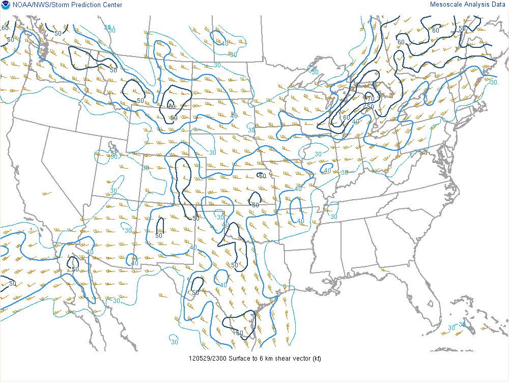
SPC had an enhanced risk area within a general slight risk very near Wichita Falls. Shear and helicity looked pretty good for supercells but I wasn't so sure about tornadoes. However, SPC did mention a risk of tornadoes within the enhanced risk area.

There was a large surface low that extended from far Southwest Texas up into Oklahoma with a front extending from the Childress area up through Oklahoma, and a dry line south of that. Winds were out of the South-Southeast across Southwest Oklahoma close to the Dry Line/Front intersection. The cold front looked like it would slowly push into Southwest Oklahoma with numerous thunderstorms ongoing ahead of it.
Shear and helicity were more than favorable for strongly rotating supercell storms along with tornadoes given low cloud bases and LFCs (Level of Free Convection). However, there was definitely concern that numerous clouds associated with very strong warm air advection and lift would yield rain and clouds early in the day preventing atmospheric destabilization. I figured all we would need was surface based CAPE (Convective Available Potential Energy) values around 1,500 j/kg given the amount of shear but I wasn't certain those values could be reached.

On the morning of November 7th the outlook hadn't really changed any. SPC was still calling for an enhanced risk of tornadoes within the yellow hatched area which also consisted of an enhanced risk of particularly strong tornadoes (in the black shaded area).

Here is the surface map at 925 mb valid for about 6am showing the strong southerly flow int the risk area. Winds were 25-30kts out of the south which is pretty significant.


At 850mb things don't look too different. Interesting divergence across SW Oklahoma and Texas. But still very strong flow overall across Texas out of the south bringing in very moist air in the 850 mb layer.

Ah, now things are getting interesting as one looks higher up into the atmosphere at the 700mb level. Winds have wipped around to the West-Southwest across the target area with a strong shortwave trough over the four corners area and a strong disturbance moving into Texas.

Now we are at the 500mb level which is considerably higher than 700mb and we have a pretty similar look overall. Winds are stronger out of the Southwest across the target area.

Figure I would look at one more 6am map. This one is at around 250mb near the top of the troposphere and well into the jet stream. Very strong divergence noted across the area enhancing lift near the surface.

Essentially everything was lined up for strong supercell thunderstorms if good instability could be attained.

Justin Terveen and I left Plano around 11:00am after a scramble to get air into the tires and we were off. The plan was to take 380 out of Denton to Decator and then take 287 up through Wichita Falls. I had also hoped to meet up with Ben Jacobi but unfortunately work obligations would keep him pinned in Wichita Falls about one hour too late. (Gotta have your priorities straight ya know).

We didn't really bother with a data check as we moved towards Wichita Falls since time was of the essence but I did do the best I could with my iPhone. First I noted that clouds were not a problem in the area in question. A good portion of the sky was clear... or at least with enough broken clouds to allow decent surface heating. This yielded CAPE values of almost 2500 j/kg just northwest of Wichita Falls into Southwestern Oklahoma by 12:00pm.

At this point I turned to Justin and said something to the effect "Remember I said I would be happy if we got 1,500 j/kg? Well we have 2,500! I think were are gonna do well today." It was just one of those moments that I knew would be memorable.

And as expected SPC issued a mesoscale discussion concerning the tornado threat in Southwest Oklahoma and West Texas.

I had really hoped that we could meet up with Ben Jacobi out on the plains, but as we moved through Wichita Falls he was still at work. It was pretty apparent that the weather was not going to wait for him. Storms were already beginning to fire in Oklahoma and far East Texas Panhandle. Given the storm motions it looked like we would driven north of the Red River fairly quickly if anything fired south of 287. At about that time the area under the mesoscale discussion was upgraded to a tornado watch given a significant threat of tornadoes. 

The storms near Childress and on northeast were already taking on supercellular characteristics. Given the storm speeds there would not be time to catch those. However, it was clear that there were numerous storms firing out ahead of the rapidly intensifying supercells and the environment was even more favorable where these new cells were. 

A storm quickly caught my attention west of Vernon Texas. It was racing north-northeast at maybe 35-40pmh. It was clear that if we wanted to catch it we needed to get to highway 183 on the east side of Vernon and take that north across the Red River. However, as we start making our play on 183 yet another cluster of small cells fires well south of 287 in Texas. These may have been as much as 40 miles south of us. However, given the motion I figured we still needed to be across the Red River any way. I didn't want to give up on the storm further to the west just yet. 

We drove into Davidson Oklahoma on north 183. At this point I began to realize that waiting on the storm southwest of us to move north-northeast towards us might be a lot smarter than running after that storm to the west. On top of that it was more isolated from the other rapidly intensifying supercells and had completely un-obstructed inflow. Meaning that the air feeding into the updrafts from the southeast was devoid of any rain cooled air from other storms. Not quite so with storms further west and north. 

It was a very hard choice though. As we sat in Davidson watching supercells to the now west-northwest explode in intensity (with at least one of them becoming tornado warned) the cell we were waiting for did a lot of nothing. Radar images of it were less then spectacular. Visually as it approached it took on a starved LP supercell type look. The reason for this was that yet another cell had fired just to its south and was dumping rain into the supercell I thought we were going to chase. The updrafts were chocking on rain cooled air from the storm to the south. Oh well, the new storm on the south side of this two cell complex would now be the target. 

This southern cell that chocked off the northern one then became THE storm of the day. And I do mean THE STORM. While tornado warnings were issued for a couple cells to the northwest I do not know of any confirmed tornadoes on those. The storm we were now waiting on to come north towards us would become a tornado producing machine called (for those of you non weather nerds) a cyclical tornadic supercell.

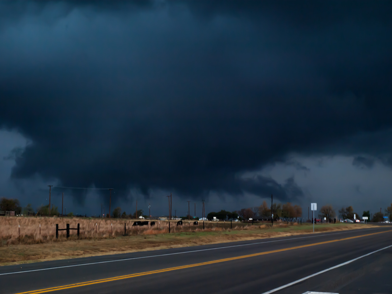
We decided it was time to move north and allow the little-bitty-baby new cell to come north and mature. We drove into the town of Fredrick Oklahoma and this is where things began to become very clear. Up until the moment we entered Fredrick we had lost radar data. Now a brand new image indicated the cell had EXPLOADED in intensity. We stopped at a gas station to fuel and asses the situation.

I just remember how excited and tense I became when I saw what was behind me. The photo is nothing spectacular but the motion and everything about the storm suggested something totally different. Here the rain free base can be seen with nearly all the rain and hail being deflected well away from the updraft area thanks to the very strong wind shear. A lowering can be seen and it had rapid upward motions indicating the presence of a very powerful updraft. The storm was showing signs of rotation on radar, though visually that wasn't so obvious just yet. However, given the almost funnel shape of the lowering and the context of where it was positioned underneath the storm all pointed to something significant about to happen.


It was clearly a scramble to find a good viewing spot. I will spare you the details of the drive through mud and cows smelling of... cows... that nearly put Justin over the edge. By the time we did find a spot to view the storm base from just south of town two things had happened:

1. The wall cloud had grown huge with INCREDIBLE rotation. The rotation was unlike anything I had seen even from other tornadic storms. And the wall cloud as practically ground scraping. It is likely that by this point tornado #1 was already in progress.

2. The sirens in Fredrick began blaring indicating that a tornado warning had already been issued.

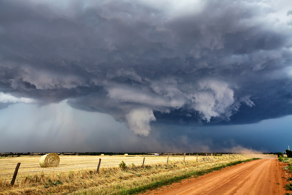
It really didn't take long for the tornado to show itself. Several little vorticies were rotating around the base of the wall cloud kicking up debris and then this tight spin up developed in the middle.


It reminded me of a drill bit. In fact, both of the first two tornadoes reminded me of drill bits given the speed of rotation.

At first I was concerned about Fredrick because I had no idea how far away it really was. It passed well west of town and nearly hit the town of Tipton. Some sort of facility in that general area was destroyed giving it its EF4 rating.

The tornado progressed quickly from its multi-vortex state into a more condensed large vortex. 


I believe it was on the ground for 39 minutes which is really significant considering most tornadoes don't make it past 10 minutes. Here it is beginning to shrink while a new ominous wall cloud develops to its east. That wall cloud would later produce tornado #2. 


Here is our last view of tornado #1. We quickly lost site of it as it wrapped up in rain on the very backside of the storm and ropped out. 

Meanwhile the new wall cloud had already put down tornado #2 in much the same way the first wall cloud did tornado #1. A small amount of debris was noticed under the very rapid rotation before a funnel developed. Here, the old tornado and the new wall cloud with its "hidden" tornado can be seen together. (You will probably have to look really hard).

The storm was still west of 183 and moving north-northeast. We decided we needed to continue after it on 183 with the expectation that it would cross the road right in front of us. Here is a series of tornado #2 as we paralleled it along highway 183.


Here is an interesting part of the story. I had been having a hard time balancing my over joy at seeing really contrasty and significant tornadoes for the first time while maintaining some level of concern for the local communities. It became very clear at this point that tornado #2 was taking dead am for Snyder Oklahoma. We knew it was going to cross 183 at some point. And Snyder was right on 183 at what appeared would be that crossing point. All I could do was pray. We had had our fun and now I thought it was a pretty good idea to talk to God about the situation. Not that it hadn't been at any other point. But it was clear that if something drastic did not change Snyder might not be Snyder any more.
About the time of the last photograph in the above series (and as we approached town) Justin decided he just had to pull over and get a shot. The tornado was entering its shrinking stage at this point. By the time Justin had pulled over gotten his tripod out, and set up the camera on it... poof... no more tornado. It simply rolled right back up into the storm base as the RFD (Rear Flank Downdraft) wrapped around it and killed it.
Justin just gave me a strange look. He hadn't even gotten to snap an image before it was gone.

It turns out tornado #2 did cross 183, but it had turned sharply to the right and crossed just south of town as it was dissipating. What a relief for Snyder any way.

Another tornado did touch down just to our east along the flanking line. That was quite a surprise! I've gone ahead and dubbed it "tornado #3" though I am not sure if it is the same one listed as tornado #3 near Snyder on the tornado track map. The funnel had been nearly all the way to the ground before this image. But by the time I had pulled my camera back out to snap a picture it had just about dissipated. All that can be seen is a very shallow cone.


The main area of rotation had wrapped rain around the south side preventing us from having a good view. From what I could tell rotation was not nearly as strong at this point. I figured the storm was either losing its steam or just going through a reorganizing faze. The amount of rain now in the RFD seemed to be blocking some of the warm moist inflow into the new wall cloud.

We had a choice at this point... continue north on highway 54 just east of Snyder. Or take highway 62 all the way to Lawton. From Lawton we could either try and catch back up with the storm on the other side of the Wichita Mountains, or we could head back home.
We wanted to stay with the storm as much as possible but there were no roads through the mountains that seemed decent, and it just overall seemed like a really bad idea even if there was. We did stop just on the south side of the mountains to catch a glimpse of a brand new tornado that had developed while we traveled east. Apparently the storm had gotten its act together again (or perhaps never lost it) and this new tornado became a really significant beast through the mountains. Some chasers caught amazing video as it tore through a wind farm in the mountains. 


Well, that was the last we saw of that tornado. I was about ready to head home at this point since the drive through Lawton at rush hour was slow and I figured we'd had about as good of a day as it could get. However, when I talked to James Langford on the phone (who was home with sick kids) he seemed to think that we could catch the storm again by heading north out of Lawton on highway 44 and then taking highway 281. So, we decided to give it a shot.

As we headed back north on 281 we saw this unique cloud band in front of us.

Called a beaver's tail, it marks the boundary between the rain cooled outflow and the warm moist inflow. Esentially the cloud band intersects the base of the mesocyclone as the warm moist inflow moves into the storm base.


The previous tornado may have been ongoing still in the above images somewhere near the area where the beaver's tail intersects the base of the storm. James kept calling us and telling us about the incredible video he was watching on the news from a helicopter.

We catch the storm again near Ft. Cobb after tornado #5 dissipates. (We never caught a glimpse of that tornado). Tornado #6 was just beginning as we entered into Ft. Cobb.

This scene was probably the scariest for us the entire day. I became a little disoriented in the trees and couldn't tell if we were headed right into trouble or not. One chaser in front of us pulled a u-turn. He obviously was not comfortable with the situation. We pulled over to get some of the structure and asses the situation. The storm clearly has a rounded base in this image. And the rotation was again second to none. Virtually the entire base from our vantage point was one giant swirl of motion. Tornado #6 is trying to get going just behind the trees above the guard rail on the right side of the base.

Realizing we were safe we continued on and captured the last tornado as it developed near Ft. Cobb. 

This tornado developed much like the first two we saw. The wall cloud gradually tightened as numerous small vorticies interacted with the ground. We also watched the TIV II drive by. Always fun to watch the TIV in action.

Here the tornado wraps up in rain and we call it a day. It was getting too dark for any kind of safe chasing. Thankfully this was the last tornado the storm produced and it was not particularly long lived compared with some of the others. The storm was moving into areas with greater population densities.

I did get one parting shot of the anvil of the storm overhead.

Despite seeing five tornadoes that day it never seemed we were far from clear blue sky. It just added to the surealness of the whole thing.

What an amazing day. And in NOVEMBER! I've only chased one other time in November back in 2008. We witnessed a lot of rain, a little lightning, and some fog. That was it.
This was the most successful chase for me from a meteorological perspective though it didn't yield the most incredible photos.

Special thanks goes out to Justin for driving and paying for gas while I sat pointing out all the things going on that he couldn't see due to his focus on the road. And that focus on the road is why I am still here today.

Justin Terveen has a time laps of this event that can be seen here.