Wednesday, October 27, 2010

Storm Chase near Wichita Falls Texas 10/22/10

This will probably be one of my favorite storm chases simply due to the fact we had more people with us than ever before and it was fairly close to home... only about a three hour drive before we were on the storms of the day. On this chase we had James Langford, Ted Van Den Heuvel, and Justin Terveen. Ben Jacobi also hooked up with us since he lived right around Wichita Falls. I definitely felt out-gunned on this one when it comes to cameras and photography skills. lol
It was an honor to be able to go out on a storm chase with such talented people.

Since Instability was somewhat low (CAPE value around 1,000) storms were not the most spectacular ever seen but they showed definite signs of Supercellular characteristics and decent mid level rotation. It was also fascinating to watch wall clouds form, spin up, and die. There were a few impressive downbursts witnessed as well, especially when a cell would begin to collapse as it entered more stable air.

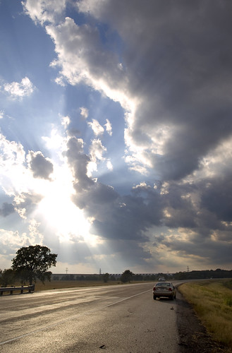
As is often the case with any severe weather events I have chased nothing is certain until a few hours before. And that was more or less true this day. Originally I had a target of Vernon Texas with the expectation that the Dry Line would set up near Childress. However by noon on Friday SPC moved the greater chance for severe weather further east and south given an outflow boundary that had set itself up west of Wichita Falls from the early morning convection across West Texas and Oklahoma. In addition a warm front seemed to become evident in the early afternoon trying to cross the Red River. To the south of the warm front surface based CAPE increased from zilch to at or over 1000 J/kg.

This was a welcome change since it put the target area closer to Wichita Falls and home. We headed out around 1:30 - 1:45 pm and arrived in Wichita Falls where we met up with Ben around 4:00 pm. Supercells had already fired along the outflow boundary near Seymour Texas and were moving to the northeast towards Wichita Falls. All we had to do was jump on highway 277 and that would take us right to the storms.

The warm front basically set itself up along highway 287 and as the first supercell began to approach the warm front the rotation in it tightened a bit given the backed surface winds along the warm front. However at the same time it began to lose surface based instability quite rapidly as it encountered the cooler air.

When I saw the northern cell develop a decent looking hook I made the call to take Highway 25 to the north to catch it near Electra with the expectation that it would turn right as it encountered the warm front and the better shear along it. However... that probably is more likely to happen if the atmosphere north of the warm front is decently unstable as well as to the south. Since temperatures dropped into the lower 70's to 60's north of the front the instability was quite low and the storm began to shrivel up... So, we turned around and got back on 277 to try and intercept the 2nd supercell coming up from near Seymour.

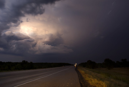
This storm also developed decent rotation as it came north near the warm front and also intensified quite a bit. When we got to Highway 183 we took that north and were able to see a pretty well developed wall cloud. By the time I started photographing the storm the wall cloud had become shallow to non-existent... but the storm still showed great structure and mid-level rotation.


It was also pretty neat to watch the strong downburts as the storm moved off to our north.

It was bout this time that the TIV II made its appearance (of which I never got a good picture). We were kind of shocked to see the TIV II out during late October.


We decided not to pursue the supercell as it continued its motion to the northeast since it had crossed 183 and was beginning to significantly weaken due to the more stable air to the north. Our attention then turned to cells to the south which at first seemed pretty disorganized.
However as the next cell approached it quickly began to show sings of having a mesocyclone and even formed a decent wall cloud (though it only had very weak rotation).


This storm was suffering from the cooler air set down by the previous storm which prevented it from getting very intense. But the wall cloud still looked good.


This storm also passed us to the west and continued off to the north east where it fell apart. But there was still a cluster of cells to the southwest and one of them as it approached quickly intensified. We went back south on 183 to get on 277 since this cell would be further east than the previous three cells.


This storm had some great rotation at the mid-levels and even developed several areas of rotation under the base... a little disorganized but intense. The rising motion in the wall clouds looked insane from as close as we were.


By this point 277 had become packed with chasers. The TIV II also made a second (or third) appearance and I again failed to get a decent picture of it due to long shutter speeds.


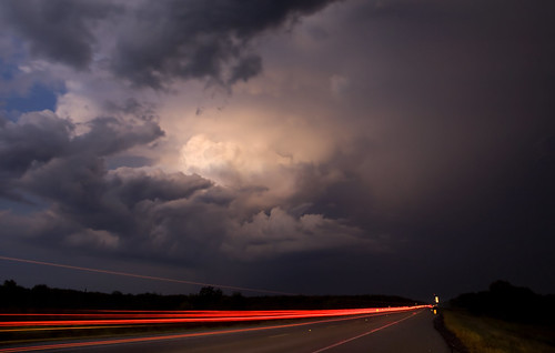
We took 277 back to the northeast towards Wichita Falls and continued to watch this beautiful storm as it also began to ingest the more stable air to the north and become more elevated.


Pretty good down burst showing up on this one.


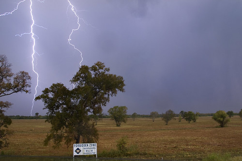
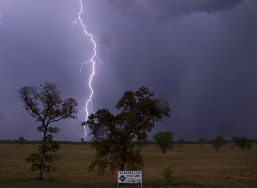
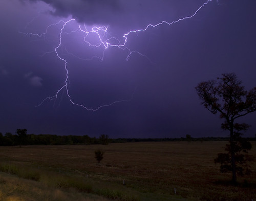
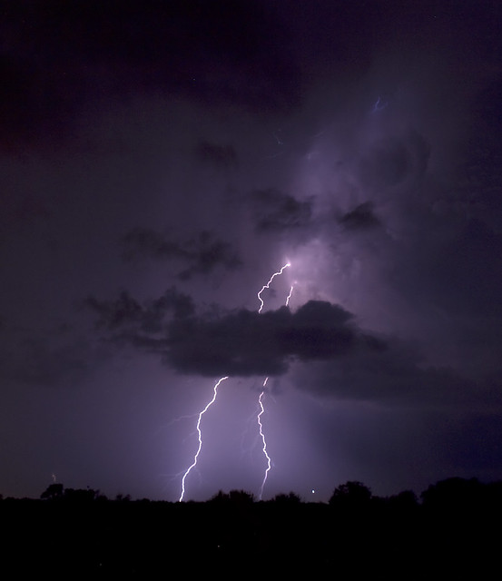
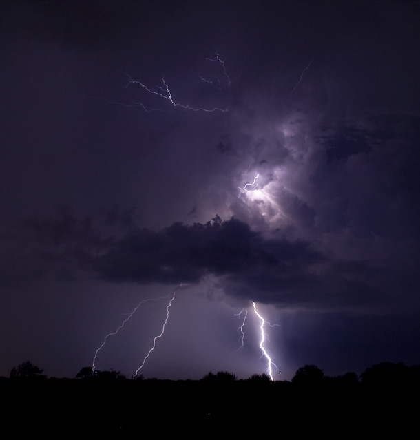
Not sure exactly where we ended the chase but it was basically along a small road north of 277 trying to capture lightning from this cell as it moved off to the northeast.


After the last cell moved off to the northeast we called it quits for the evening, said good bye to Ben, then headed into Wichita Falls to begin the trip home.
All in all it was quite an amazing chase... especially given that it was October.

Thursday, October 21, 2010

Chasing Friday - Its ON!!


Well, it has been decided and we are going to head out around 1:00 - 1:30pm. Hoping to be up northwest of Wichita Falls by late afternoon/early evening for a potential round of Supercells.

The big issue will be clearing out all the rain and storms up in that area to allow for some surface heating in the afternoon as the dry line tries (kind of sort of) to make a push to the east from around Childress - Texas Panhandle/Oklahoma boarder. Right now the HRRR (High Resolution Rapid Refresh) model indicates storms will still be in that area in the mid morning hours (yuck) but with all the convection dissipating and trying to push out of the area towards the northeast. Really looks like the vast majority of Oklahoma will remain too wet and cloudy to build up enough instability for any major outbreak of severe storms as all this "junkvection" overspreads Oklahoma throughout the day. But, the southwest corner of Oklahoma/northwest Texas looks promising if it clears out.

The latest run of the NAM (00z) shows the highest CAPE up there that I have seen forecasted thus far with values approximately 2,000... little less... but close.

Forecast Sounding from Vernon Texas at 00z.


The one thing that we will have plenty of is shear. It looks like there will be at least 45 - 50kts of 0-6km shear... which is very good and low level helecity could support the development of a tornado or two as long as there is some surface based instability for storms to work with.

All in all, I think we will have a good time... provided expectations aren't too high ;)

Tuesday, October 19, 2010

A Chase Friday Looking Likely


I don't really like the fact that the Storm Prediction Center has yet to outline a specific severe weather area for Days 4-8 on their outlook page. That should tell me that any forecast I have is still primarily pure speculation and still can't focus too much on the current details of any one model solution.
But, I still think that given the way the GFS and NAM, as well as the ECMWF, look a chase to the northwest somewhere is likely on Friday and would like to take a look at what this system has going for it.

CAPE Friday Evening @ 7pm from the 12z NAM

The Same from the 12z GFS

The atmosphere just doesn't seem to be as unstable as I would intuitively think it would be given the amount of surface moisture being advected north into the system. This could be due to significant cloud cover with the low level jet at 850mb pumping that moisture in.
Also, there will be no shortage of lift over Oklahoma and North Texas by around 12pm... which has me a little worried that storm initiation could be earlier than expected and storms might push further east... possibly east of I 35 by late evening.

Look at the Jet Stream Positions from the NAM @ 250mb:

From 18z (1pm) and 00z (7pm)

Up until a day or two ago I would not have really known how to use this. (But thanks to Professor Robert G. Fovell I will give it a shot.)
There are some very key areas of lift typically seen near Jet Streaks like this.
One area of lift is the left front exit rigion and the other is the right rear entrance region. If you look at the Jet Streak along the Red River at 18z you should notice that all of southern Oklahoma is in the left front exit region of the jet. And by 00z all of Oklahoma (just about) is. (GFS has its Jet Streak positioned basically the same).
I would expect from this that significant lift will be in place starting around noon and continuing into the late evening. Overnight it starts to push further east along with the low level Jet at 850mb which really strengthens 0nce the sun goes down along and east of I 35.

But here is the interesting thing to me... I would expect the surface low to also move to the northeast and shove the Dry Line towards or across the I 35 corridor... but none of the models really show this happening. They all keep the Dry Line west of I 35 right now... in fact almost to the Oklahoma Texas boarder.

12z NAM surface Dew Points @ 18z Friday

12z GFS surface Dew Points @ 18z Friday

NAM surface Dew Points @ 00z Friday

GFS surface Dew Points @ 00z Friday

So, if all of this actually comes about just like the models indicate I am not 100% sure what will happen. But I would expect some storms to form in the early afternoon and push east fairly quickly (maybe the low level jet convection we often see?) and perhaps another round of storms firing off of the Dry Line to the west where the best instability and surface convergence are.
So, right now it looks like my favorite spot to be would be north of Wichita Falls Texas (perhaps near Lawton or further north) in the mid afternoon.
I believe our best bet at this time would be to shoot straight north along I 35 and then turn to the west towards storms that fire off of the Dry Line. I am not sure whether we would want to go all the way to I 40 or not... but that is where the models seem to want to break out convection at this time.

So after writing all of this up I still must remember that this is all really all educated (I think/hope) speculation on my part.

Saturday, October 16, 2010

Monday's event going downhill... eyes on the weekend.

Looks like if there is a chase opportunity it will be more towards Friday or Saturday rather than Monday. The models (the NAM and GFS) have come in with less moisture return than what was being shown by the GFS on Thursday. NAM is the driest with Dew Points mixing out at the surface down into the mid 50's and while the GFS fails to bring 60 Dew Points to the Red River until Midnight Tuesday morning. CAPE (Convective Available Potential Energy) has gone down on the GFS while CIN (Convective INhibition) has gone up and shear has not changed much with each run of the models with the NAM indicating the less shear over North West Texas/West Oklahoma. Given these factors it looks like I won't be heading out to chase on Monday unless the models come up with a drastically different solution. There still might be some opportunity for lightning as the front moves in early Tuesday morning.

Surface Dew Points from 18z run of GFS for 7pm Monday.

Surface Dew Points from 18z run of NAM for 7pm Monday.

500mb Level and Wind Speed from 18z Run of GFS for 7pm Monday.

500mb Level and Wind Speed from 18z Run of NAM for 7pm Monday.


My attention is still drawn towards the weekend when the closed low begins to open up and lift out over North Texas/West Oklahoma. The ECMWF and GFS both want to dig yet another trough in behind this one keeping us under the gun as these systems lift out over the southern plains through the start of next week. I figure with as much southerly flow expected the later part of next week into the week after that at least one of these systems will have good moisture to work with.

Thursday, October 14, 2010

Active Pattern Next Week

Well despite just having gone on a chase it looks like there maybe another opportunity coming up on Monday, and then perhaps another towards next weekend.

Right now it appears that a strong trough cuts off at 500mb and slowly drifts east, providing an opportunity for storms on Monday... and then perhaps later in the week as it lifts back out into the main Jet Stream.

At the surface it looks like plenty of moisture will advect north out of the gulf without much problem in time for Monday's event. Flow looks to be nicely backed out of the east-southeast near Childress Texas.

The main concerns right now appear to be the ridiculous cap forecasted to be in place and the weak flow at 500mb. It looks to me that the ECMWF might have some faster flow near 500mb given the way its hight lines are spaced and the position of the trough. But I don't really know how it is distributing that flow around. As for the cap, if there is too much cloud cover on Monday from all the moist air advection than it is likely the surface heating that would be needed to help erode the cap will not take place.

There might be some opportunity for chasing on Tuesday, but with a cold front pressing south into the Metroplex it looks like the mode of storms wouldn't be too favorable for chasing.

The next opportunity after Tuesday looks to be around Friday or Saturday of next week, and right now looks to me like it holds more potential (given the current GFS forecast). But things can and will probably change as the week goes by. At least it looks like the models want to keep strong troughs in the west for the foreseeable future which would keep us in the active weather as long as they keep lifting out over the southern plains.

Wednesday, October 13, 2010

Awesome Lightning Near Corsicana 10/11/2010

Well, I did decide to chase Monday's event (thanks to James Langford who now-casted for me pretty much the entire day) and wound up shooting south-southeast on I 45.
Initially things were not too interesting, but as the front began its slow progress south while I sat on 287 between Palestine and Corsicana thunderstorms erupted jut about right on top of me. I experienced some pea to dime size hail and some cool lightning.

Shear on this day was in the 25 - 35kt range I believe... but flow in the low levels was very weak and disorganized until you got up past the 700mb level or so. Some storms did show periods of Supercellular behavior, but most cells didn't. Cape was not too bad this day with values around 2000 j/kg or so.

I started the chase around 2:00pm from Murphy Texas and headed for cells that had already developed along Highway 31 east of Corsicana. I reached them around 3:30 - 4:00pm. One cell in particular showed superculler characteristics, but not for much of the latter part of its life when it bowed out and became embedded in a mess of cells moving off to the east-southeast. I got suckered after this cell... but never reached it as it remained south of 31 and was moving away from me and home. I did head on into Athens only to have my view completely blocked by trees.

By the time I reached Athens all the cells near me appeared to weaken and become fairly disorganized on radar, but I continued to have hope that new and better storms would fire off to my west closer to I 45 in the latter afternoon. I shot south on Highway 19 out of Athens to try and get back to the boundary that storms were firing off of to my south. Trees still plagued my view of the sky and I missed an awesome rainbow due to not having a place to pull off when there was a view. I arrived in Palestine and took the quickest route back towards I 45 which was 287.

When I reached the Richland Creek Wildlife Management Area my view suddenly opened up and I could see everything around me for miles. The road went over several overpasses in that area and was elevated above the surrounding countryside by about 15 feet.


I decided then and there that that was where I needed to be and there I remained from about 5:30 - 8:30pm.

The main bulk of storms pushed off into southeast Texas and Louisiana by this time and the front (which was now sitting just to my north by about five miles) was slowly marching south. New cells tried repeatedly to fire off of the front and some tried to my south. Around 6pm storms began to take off right on the boundary and almost directly over me. And that is when the fun began. I sat on 287 while a couple of cells intensified to my north and east. Another cell got very intense just to me west shortly after the ones to my northeast began to intensify. All storms were drifting to the east very slowly. I decided to let the more intense western cell pass overhead as there were no warnings on any of the storms and couldn't think of a better spot to be as far as visibility.

A cell to my east-northeast also got fairly intense and showed some signs of weak rotation on radar. Under the base a small cone shaped lowering formed and persisted until rain from the western cell moved overhead and blocked my view of it.


Once it disappeared I experienced the hail from a left split off of the cell to the west which lasted about a minute or two. What fallowed was a pretty intense display of lighting just a few miles to my south from the right mover that was now beginning to drift to my south very slowly.


I'd been hanging on this stretch of highway about an hour and half or more by now, using the hazard lights and charging the iPhone the whole time, when the battery goes dead. Ooops! Well, I call Dad and let him know of the situation and he decides to come and jump start my engine (despite the fact I am two hours from home). On the bright side I would have a spectacular view of lightning for the next hour or more at this location the way things were moving. Thankfully a hunter stopped by on his way home and jump started my car long before my Dad would've reached me and Dad didn't have to make the long drive from the north side of Dallas. I left soon after the car started as I was afraid the car might die on me again. But, from the time the car died till it got jump started I was able to grab a few images.


All in all it was well worth getting out seeing a few good thunderstorms.

Sunday, October 10, 2010

Looks like the forecast is somewhat confusing for Monday.
Storm Prediction Center is not as concerned with the storm potential today as they were yesterday.

So, what are some of the positives for storms tomorrow at this point?
Looks like we will have at least 60 dew points by Monday morning, and flow at 500mb is close to 30kts (not real strong but enough to organize some storms). NAM and GFS both indicate CAPE values around 1500 with the NAM runs coming up with some 2000 CAPE near I 35 and close to the DFW area. Lift seems to be moderate over the area as well and pockets of decent lift remain over the area through the evening (though the best lift looks to be east of the area in the afternoon).

What is not looking so good?
Surface boundaries are hard to find. The NAM seems to have a basic Dry Line feature sitting west of I 35... or maybe it is the cold front. Winds behind that are out of the west-north-west or northwest, which is fine, but ahead the flow is confused and or non-existent.
The GFS has west winds all across North Texas and begins to shunt the moisture off to the east into far East Texas by early afternoon and never really develops a dry line/front feature.
Both models never really develop thunderstorms west of I 35, but keep a complex of storms going in East Texas.

The 18z run of the NAM Surface Pressure and Wind shows some winds backed out of the east along the red river... but... really can't focus too much on these small scale features since they tend to change up quite a bit from run to run. It could simply be outflow from convection the model thinks is currently ongoing near the Louisiana boarder.

If the NAM solution verified (the most optimistic of the two models I have been looking at) then we could still be looking at a threat of some severe weather activity if the lift over the area combined with surface heating also combined with any surface boundaries proves to be sufficient for storms to initiate. Laps rates aloft a pretty steep... so updrafts shouldn't have a lot of trouble getting going once they can lift through any CIN over the area. Even then that is no guarantee that storms will even initiate or develop much mid-level rotation... though I still think that is a distinct possibility (with the NAM solution). At least we would not need to go far in any particular direction... unless we really wanted to head down I 45 into the core of the slight risk area.

The other issue is even if all goes well and we get a storm to develop a mid level mesocyclone within our range how long will it last? Once the sun goes down we will lose surface based instability fairly quickly. So, lightning photography opportunities might be very short lived.

Saturday, October 9, 2010

Thunderstorm chances improving for Monday

The Storm Prediction Center has a slight risk over us right now for Monday.


This sounding from the NAM at about noon Monday right around Sherman Texas looks pretty good. Pretty steep laps rates and surface dew point of almost 20 C (around 65 F). Also, wind shear seems to have improved with this run of the model with 0-500mb shear of around 35 kts across the Red River Valley area.

However, at this point the best lift is right over top of the metroplex and there is no capping inversion to help hold of convection for later in the day. See the Vertical Velocity over the metroplex at 18z. By about 00z, or 7pm most of the lift has moved off into Oklahoma, with even more lift showing up in Central and Southern Texas. We still have some minor lift over the area, but if surface instability has already been exhausted at this point than it won't do us much good.

So, the problem now seems to mainly be the time of day. If storms do linger or develop later in the day I or some of us may go chasing. But, if things blow through too quickly that isn't going to happen. I hope that something will linger after dark Monday evening so that we can grab some lightning, but that might be too much to ask for at this point.

A note about Sunday...
Sundays activity seems to be limited by a lack of good surface moisture mainly, though the Storm Prediction Center does have a slight risk over Northwest Texas and Western Oklahoma. It will be interesting to see whether or not anything comes of that.

Friday, October 8, 2010

Sunday and Monday Thunderstorm outlook.

So, it has been a long while since we have had a shot at some good non-airmass thunderstorms and looks like a chance is coming up this weekend. Unlike the past several months we will actually have a very deep trough swing through Oklahoma and Texas! However what we don't lack in upper level support we might actually lack at the surface: Good moisture return from the gulf and decent surface heating. Another problem for those of us who like to chase these things is that any storms that form will likely blow through in the morning hours (one main disturbance Monday morning and the other Tuesday morning).

Here is the 12z GFS at 500mb Sunday evening.


Same model and run for Monday evening...


Here is what the NAM shows at 500mb for Sunday evening... and for Monday Evening.


Here is what the GFS says about surface Dew Points for Sunday Evening and Monday Evening.


The NAM for Sunday Evening and Monday Evening.


The GFS is definetely more aggressive with the moisture flow out of the gulf. The good news is that the NAM has been increasing the moisture over North Texas over the past few runs. The 00z run has not finished but it is bringing Dew Points up into the mid 60's.


This is what the ECMWF shows for early Monday morning. Looks like it has a surface boundary sitting just west of the Metroplex, and it does not push that boundary through the area until early Tuesday.

I did find it interesting that SPC does have a "See Text" area on their day three convective outlook for Sunday. From what the models show if anything happened it would be way to the west and probably wouldn't initiate until after dark.


There has been some discussion on what could happen Monday afternoon after the first disturbance blows through. If the atmosphere can destabilize enough (if given enough moisture and some breaks in the clouds) then something interesting could happen.

Shear would be another tricky thing to forecast in this situation. There is not a very strong jet streak with this trough. And where the faster flow aloft will actually set up who knows.

Again something to keep an eye on. I would like to be able to get some lightning photographs if one of these disturbances will actually develop decent enough storms.