Unlike how the next days forecast would turn out this days was actually pretty good. Primarily because the models did a fairly good job and I had actually been looking over things carefully.
Chased with Justin Terveen, James Langford and Krista Higbee. Krista came on behalf of D-Magazine which was really neat. Hopefully I didn't say anything too stupid. ;)
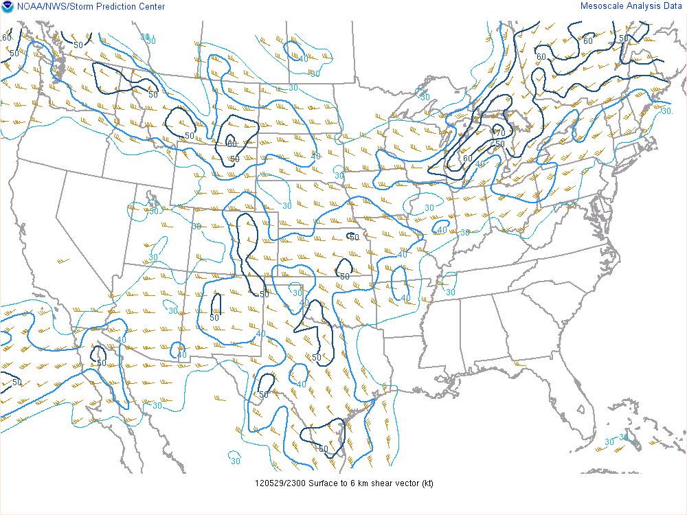
The day and the next would be characterized by broad upper level flow across the central U.S. While not overly powerful it seemed as if it would provide enough deep layer shear for supercell thunderstorms. Around 35kts of shear, as it turns out, certainly ended up being plenty. Instability wouldn't be a problem either as it maxed out at about 4,000 j/kg near the Wotonga/Kingfisher area.
The Actual Sounding from Oklahoma City at 7pm only indicates ~3,000 j/kg and 33kts. Mesoanalysis on the SPC site would indicate 40kts or so with nearly 4,000 j/kg.
OKC sounding 7pm

SBCAPE 6pm

0-6km Shear 6pm
The primary focus for storms would be a frontal boundary draped across the northern portion of Oklahoma a dryline to the west and strong convergence near the center of the surface low. In addition a disturbance would be rippling through the mid-level flow providing for additional lift.
The target area was essentially Watonga to Woodward Oklahoma. An area that was fairly close to the surface low and with surface winds backed to the southeast rather than south. This would enhance the overall shear and helicity just a bit more despite the lack of low level shear. Winds up to about 3km were pretty much aligned with only a bit of speed shear. So tornadoes were not really something I was expecting.
However, supercell thunderstorms in the right environment that latch onto boundaries or experience odd interactions with nearby cells may not care that low level shear is weak. This has been a well noted fact and why many chasers want to see a supercell thunderstorm interact with some kind of boundary. It all has to do with how winds change on a boundary and how low level shear and helicity might be considerably higher in the inflow region of a storm that is interacting with a boundary.
The reason I bring this up is because the storm that impacted the Kingfisher/Piedmont area produced a tornado (more than one?) despite the lack of low level shear and helicity after colliding with the outflow from another powerful storm to its south. What an incredible meteorological phenomenon that was to watch! Both storms then quickly fell apart after ingesting each others outflow.
Once on I 40 we teamed up with the DOW (Doppler On Wheels)... or more like passed them. It was, however, encouraging to see them heading the same direction we were.
We arrived just north of Watonga around 3pm and waited for storms to initiate. This consisted primarily of watching puffy cumulus clouds get bigger and bigger while we were getting sunburned. Finally noted some high clouds on the horizon just after 4pm associated with a beefy area of cumulus and assumed storms were firing.

The storms were slow moving and yielded some incredible explosive updraft motions. For a time we were able to sit under the developing mesocyclone as it organized near the town of Okeene while spitting some penny to nickle sized hail at us. This storm was also the southern most cell in a line of storms and therefore had the least obstructed inflow out of all of them.
The storm passed just to the northwest of Okeene by only a few miles. Interestingly the sirens in Okeene were blowing and we never knew the reason for it. The storm was high based at the time and there was no wall cloud (though mid level rotation was quite strong). There appeared to be some smoke in the town and perhaps a fire was the cause. Also, a number of dry microbursts were noted just north of town where the RFD was likely taking shape.
We were really cut off at Okeene since the storm was moving southeast right over highway 51 and there were no decent roads to take to the southeast to stay with the storm. Core punching was not really an option for those of us who dislike being beaten with large hail. We could've stayed on dirt roads but that is always a bit risky. We decided to drop south on highway 8 and then find another eastbound option.
I believe that eastbound option was Loyal Road as it was the only paved option and I don't even believe it was paved the entire way.
Whatever the road we took it east a little ways and that is when the storm started developing wall clouds. The first few were exciting... but not terribly exciting. (Actually most wall clouds for us are terribly exciting.) But with each wall cloud the storm would cycle through they would get lower and rotation would become stronger. In fact, the rotation at several points became very pronounced and very close to the tornadic storms I could compare it to. It really makes me wonder if it would've eventually put down a tornado anyway as it continued on into deeper moisture while surface temps cooled a bit in the evening. But we will never know since the storm collision of awesomeness took place at the critical "magic hour".
The first Wall Cloud by Justin
Another Wall Cloud by Justin
Wall Cloud image by James Langford
We dropped south out of Loyal to highway 3/33 and headed east into Kingfisher. It was about at this point that the storm was producing the Softball to Grape Fruit sized hail. Certainly not a storm we wanted to be cored by. We didn't really have time to stop as we barely made it through town before the storm as it was. Inflow was very impressive as well.

There was another cell immediately two our south that we had noticed earlier in the day. Not entirely sure where it originated, but it was likely a left split off of some storms closer to the Red River. It shot north at a fairly high rate of speed and was essentially on a collision course with our cell. The updrafts were extremely impressive with this cell as it came towards us. The situation was somewhat problematic for us because it looked as if we would be caught between the cells as they collided. Thankfully we were able to stop on the south side of Piedmont and just watch the process unfold.
The sky was simply crazy with stuff going on. We had the original cell to the north which was sucking in the outflow from the southern cell coming north and this made for tremendous wind at our location (tremendous being 40-50mph). We didn't have a great view of the southern cell as it merged given its meso was somewhat hidden at the angle we vied it from (the tail end of the RFD region I guess). So, we were most interested in the meso to our north on the original storm.
I can't really describe it but James' and Justin's pictures do a pretty good job.
Picture from James of the mesocyclone containing the developing tornado
Picture from Justin of the mesocyclone
Panoramic Image of the Mesocyclone from James
Panoramic Image of the Mesocyclone from Justin
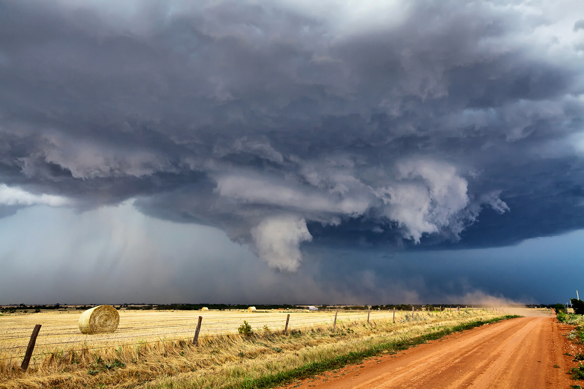
There were actually a few areas of strong rotation, but the main circulation that the rain was wrapping around right in front of us produced the only known tornado.
Video of the tornado by James
Photo of the Tornado by Justin
The tornado was very brief but surprising to me. I had seen the circulation wrap up earlier and thought that it was done given that it appeared to have completely occluded. But the rain thinned out for a moment and there the funnel was! Thankfully it was brief and there was very little if any damage.
Another interesting point is that as this process unfolded the storm base seems to have raised. Likely due to the updrafts being chocked to some extent and the storm weakening. But it was right at the end of that that the tornado appeared.
The above radar loop should tell the rest of the story. The cells merged and spun up then immediately collapsed after ingesting each others cold outflow. We then had to find a way to get out of Piedmont and back south as another supercell quickly blew up on the outflow boundary set down by the original storm we were chasing.
We managed to make one stop in Union City for lighting on this new cell before having to flee to the south again. At that stop there happened to be a civil defense siren not more than 50 feet from us. A tornado warning was issued for this new storm and the siren went off. I really didn't know how load those things were until now. As it made its sweep towards us the ground actually was vibrating.
New Cell Mesocyclone by Justin
Some lightning out of the Meso by James. Possibly from a different stop.
Another from Justin
The day ended after a quick gas up stop which was cut short thanks to the new monster storm sneaking up on us quicker than expected. Given the 75mph plus winds expected with it along with the huge hail we figured we didn't need a full tank.
We quickly got back on I 35 and took it back home to Dallas where the large complex of storms eventually had an impact later that night.
In looking back all I can say is wow. The one day that we get somebody from D-Magazine to come along is the day that the forecast actually verifies and everything down to a tornado is witnessed. Wish I could say that my great forecasting skills was to be blamed for this but it isn't really. While I might have some (that God gave me) I am not the one who controls the weather.


