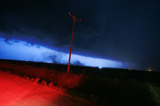
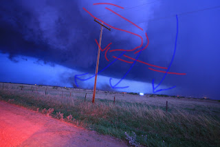
All Photographs courtesy of Justin Terveen.
I have enhanced them and even scribbled on some of them.
So, I thought I would go back and review what little evidence we have of the "whirling dirt cloud" on May 19th just to see what the possibilities of it being either a gustnado or tornado were.
It was definitely one or the other, but I more or less called it a tornado while others have wisely said that there really isn't enough evidence to declare it one or the other.
So first I'll review my memories since it is so much fun to do so... and just in case you decided not to read the long May 19th account:
I am setting up to shoot lightning and manage to get two (or three) shots off before I decide its time to make a run back to the vehicle.
Its twilight and there is just enough light to see the edge of the dark cloud against the heavy rain shaft and it appears to be a typical outflow cloud. But visibility aside from the aid of lightning is really bad.
I get within twenty feet of vehicle and notice a hissing sound with growing dust cloud off to my northwest. The column of dirt is definitely rotating.
Justin and I are scrambling to load our gear into the back of James' Tahoe when it hits and at first the wind seems to be more or less coming from my left.
I manage to get my tripod in the backseat but nothing else as I am blown sideways past Justin by incredibly strong winds now coming from my right. My camera snags on his tripod and I let go for fear of damaging something and continue to stumble to the left of the vehicle as the winds push me away.
Now for the photographs:
I drew in the lines to show where it looks to me like a spiral pattern in the cloud base. I believe you can already see the start of a dust cloud underneath the "cone shaped" nub.
These shots were taken immediately after we were settled in the vehicle trying to regain our composure.
I drew in where the RFD appears to be in this image and the boundary between the updraft base and RFD slot along with a red V outlining a possible cone. It seems I can at least rely on the shape of the clouds in the foreground since an instantaneous flash of lightning is what's illuminating them.
So, what are the issues we have with the photos?
Since none of us could actually see the motion in the cloud base we can't be really sure that rotation was present. Still... the photos seem to indicate to me that rotation is indeed very possible... especially given the shape of the RFD notch in the last image. But I have no real idea of how pronounced it was, and that nub is kind of small.
Another issue we have is how close the downdraft is to the dust cloud. So it is also very plausible that the dust is from a gustnado.
The radar data is kind of interesting, but does not indicate any kind of tornadic activity. I figured with the radar being so close to the storm that if strong rotation was present in the low levels we should be able to see it.
First is reflectivity as close to the time of the incident as I can figure.
The white rectangle is basically the area we could've been in. James said we were about three miles north of Grandfield which is about where the bottom of the rectangle is. The top part is as far north (or further) as seems conceivably possible for us to have been. We do have an RFD surge and indications of a decent mesocyclone.
Next is a set of the lowest level SR-Velocity scans. Times should be the same as above.
Gee, if there was tight rotation it sure isn't showing up here. There is a mesocyclone with broad weak rotation, but nothing more according to this set of scans.
Let's go higher with a 2.4 dgree tilt to the SR-Velocity.
I think this is even less impressive than the lower tilt.
So what I can conclude is that while a weak tornado is not out of the question, it sure seems like a gustnado is more likely given the radar presentation.
Something that also really bothers me is that I don't know the exact location of where we were. The center of rotation sure looks to be too far north. But what we experienced given the shape of the downdraft and such seems to indicate that we were underneath the meso, or on the north side of the RFD.
I think I am going to just have to admit defeat and declare gustnado knowing that we will never really know for sure.
Either way, thanks be to God no one was injured.
Edit:
After James Langford reviewed the video we have decided we were further north near the inflow notch. Possibly over 5 miles north of Grandfield. This would put us under the mesocyclone... but it is still no proof of a tornado.


I found your blog, Zack... THB.
ReplyDeletePS... YOUR BLOG IS SO BORING!!! (typical)...
ReplyDelete